Geo Smart Civil is using a state of the art technology to perform accurate dimensional models.
- The software is an important and impressive part of 3d data analysis. Geo Civil is using a variety of software to serve multiple applications like Cyclone, Autodesk plant, Autodesk Revit, Arc Gis…..etc.
- The modeling team is well trained and continuously under skills upgrading program with backgrounds in civil engineering, geomatics engineering, mechanical engineering, naval architect, architect, interior design, shipbuilding, and surveying.
- We are following high standards of HSE procedures and personnel training to save our persons and the company vision.
Tank analysis by laser scanning
We offers a complete line of 3D scanning and measurement technologies as well as contract measurement services for 3D scanning, reverse engineering, mechanical inspection, 3D Modeling, and Plant Modelling.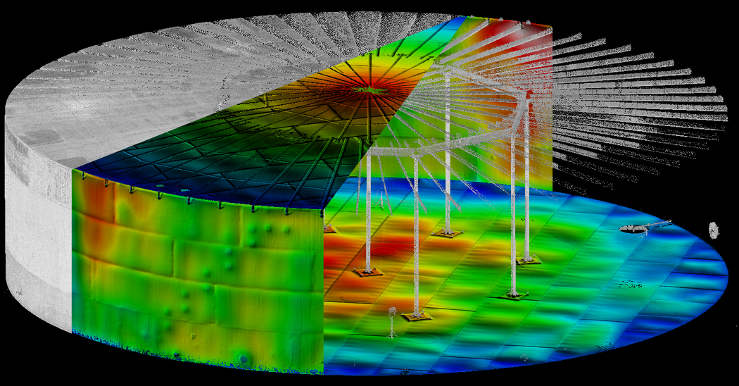
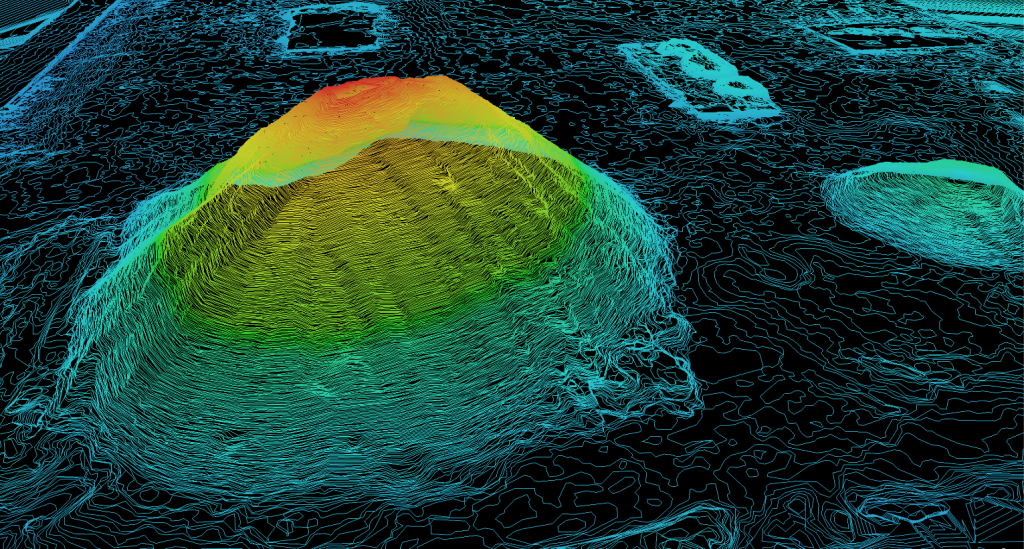
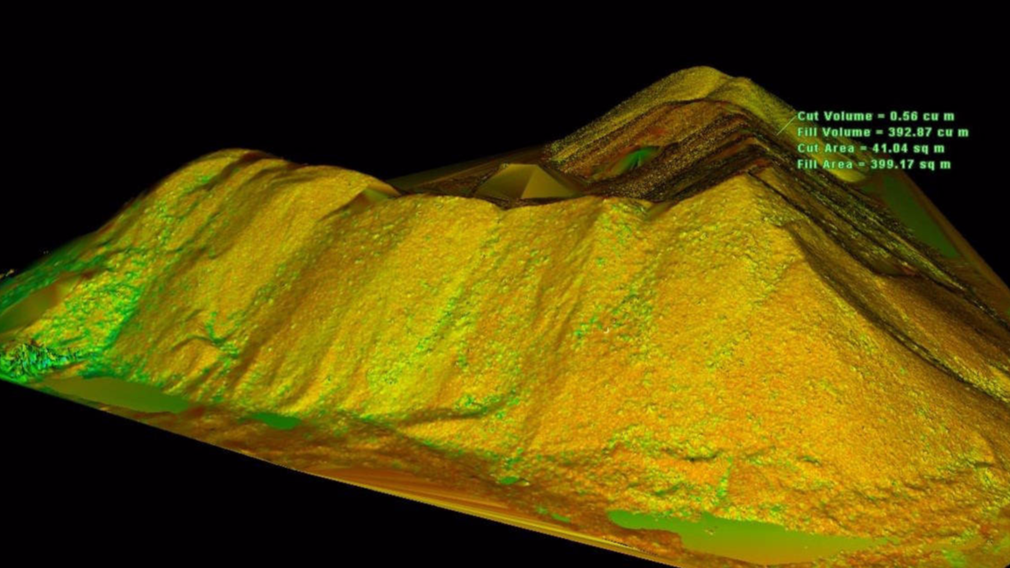
Stock piles Calculations by Drone
Geo Smart Civil employs a full-time professional staff & Equipment enabling us to provide a full range of professional Aerial Survey services.
We hold multi Kind of UAV (Unmanned Aerial Vehicle), some of them are Multicomputer used for simple land survey or Media records. Another equipment uses a Flyover route, usually, we use it for Mega Projects and non-accessible regions. Our UAV’s controlled by Computerized navigator Used as remote sensing instrument to capture Ground Surface details on 500m Altitude. Exported Data used as GIS-Based Ortho Photo, Generate DTM & DEM, Creating Contours, Volumetric Reports, or simply an aerial still / Oblique photos.
Advantages Of UAV:
- Imagery provided that no map can equal
- Improved data high-resolution aerial imagery
- Limited ground access required on site
- Quick mobilization
- Small window required in bad weather
- Use of high-precision photogrammetry
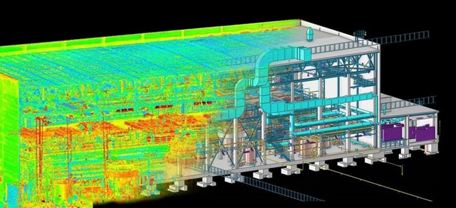
Bim Modelling
Building information modeling or what’s known as BIM introduces a whole new world on so many different aspects such as time and cost-saving, much higher accurate estimations and narrowing error margins.
Instead of having separate sets of drawings and layouts for your project, BIM gathers them all in one intelligent model showing all the connections and links between the vital parts of the project.
3D modeling and information management are some of the great features which BIM introduces. You can see and manage all your data while tracking the timeline and the work process day by day.
The level of details or (LOD) tells how detailed you want your model to be or what are the important details for you. For example:
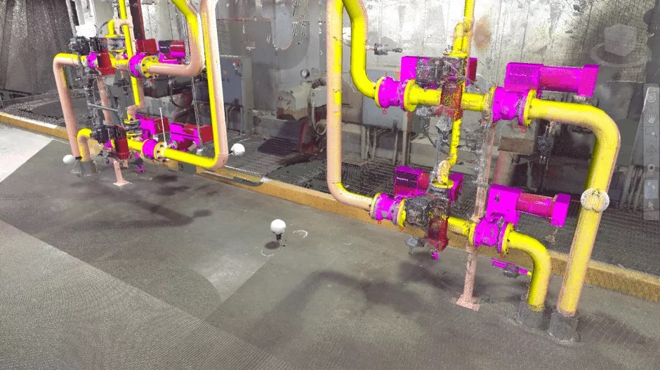
Point Cloud Picture
- LOD 200 The Model Element is graphically represented within the Model as a generic system, object, or assembly with approximate quantities, size, shape, location, and orientation. Non-graphic information may also be attached to the Model Element.
- LOD 300 The Model Element is graphically represented within the Model as a specific system, object or assembly accurate in terms of quantity, size, shape, location, and orientation. Non-graphic information may also be attached to the Model Element.
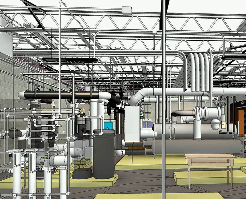
As shown in the picture below you can see the difference between the introduced details in each LOD.
Geo Smart Civil is one of the pioneers in this field, it was one of the few companies in the UAE to start working in this scope. Geo Civil has created and produced BIM models – Locally and globally – in so many different areas such as MEP models & Steel structure models & Building models and Infrastructure
Geomatics Professional Services Such As:
- Prepare and maintain sketches, maps, reports, and legal descriptions of surveys in order to describe, certify, and assume liability for work performed.
- Verify the accuracy of survey data, including measurements and calculations conducted at survey sites and related reports submitted by the Consultant and Contractor.
- Preparing the cadastral map in ArcGIS of the project affected areas for the purpose of compensation distribution/ resettlement/ rehabilitation as required for the project development.
- Training the student’s and Customers GIS, Remote Sensing Technology.